|
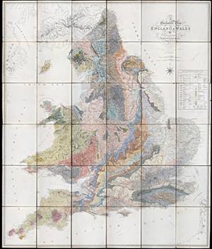
| First edition of Greenough's 'Geological Map of England and Wales (1820) |
When the Geological Society was formed in 1807, the science of geology was very new. So new in fact that its members spent the first few years attempting to collate what was known about the subject, even requesting help from the general public. As data and specimens poured in what became clear was the virtual absence of geological maps of the British Isles.
|
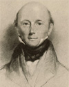
| George Bellas Greenough |
Therefore on 7 April 1809 the Society formed its Committee of Maps, stating “...the construction of Mineralogical Maps and the collection of Drawings, Models, Sections of Mines, &c, are well worthy the attention of the Geological Society, and cannot fail materially to promote the objects which they had in view of associating.” In July 1810 this had developed into the ambitious plan to create a geological map of the country. In November 1812, our first president George Bellas Greenough (1778-1855) presented a draft map which had the rudimentary strata for England and Wales marked.
The Society was aware that William Smith had also been attempting to create a map of England and Wales. In 1808 a delegation of Members of the Society, including Greenough, paid a visit to Smith to see his fossil collection and maps as part of the early fact-finding missions. Apparently they came away not fully convinced by Smith’s fossil theories nor impressed with the slow progress of his map which had by then virtually ground to a halt. However in 1812 Smith had finally found a publisher, resulting in both maps being in production at the same time.
Unlike Smith’s map which was principally the work of one man, Greenough’s map (as it is popularly called) is the first crowd-sourced map. It was initially collated from the information which had been sent in, but up until its publication in 1820, Greenough was still encouraging Society Members, mine owners and other interested parties based in the regions to share their local geological knowledge in order that the map be as accurate as possible.
Smith’s map came out first and both the Society and Greenough received copies from the first batch produced around September 1815. This would prove controversial as of course Greenough now had access to Smith’s work which he acknowledged he did consult. How much he made use of it is unclear.
Greenough’s map was not published until 1820 due to the problems with the base map. Existing maps were considered not good enough and the estimates to re-engrave them too high. Instead the base map was created from scratch, but being rather pernickety Greenough kept asking for modifications. The base map would take nearly five years to produce and cost far much more than if an existing map had been re-engraved. In the end the total production costs were around £1720 which is about £100,000 in today’s money. The wealthy Greenough and his fellow map committee member Henry Warburton (1784-1858) underwrote the cost between them on the understanding they would be paid back from the sales.
Around 325 coloured maps were produced, with 33 given away free to other institutions. Whilst Warburton got two thirds of his money back, Greenough got nothing.
Greenough’s map is more accurate than Smith’s because he used multiple sources, whilst Smith, strictly bound by his stratigraphical theories, would add strata in areas where he presumed they must be but did not in fact exist.
The Greenough Map was issued with updated geological colouring in two further editions in 1840 and 1865 respectively.
Discover more by visiting our online exhibition Making Maps - George Bellas Greenough's mapping of the British Isles