 Andrew Harrison*describes Dudley’s great geological site, the World’s first NNR, a year on from its 60th birthday.
Apart from heavy industry and being the birthplace of Sir Lenny Henry, Dudley is known for one important but often overlooked geological gem. Wren’s Nest is internationally known for its fossils, and in September 2016 it celebrated its 60th anniversary as the World’s first National Nature Reserve. The accolade was granted in 1956 during the post-war recovery period, when the Council were looking for green spaces where local people could find peace, reconciliation and inspiration.
Picture:Calymene blumenbachii or ‘Dudley Bug’. Courtesy of Dudley Museum Services.
An important location for fossil-finding, Wren’s Nest stood out as a site requiring protection. A nominated Site of Special Scientific Interest (1991) and a Scheduled Monument (2004), it is valued for its geology, industrial heritage and wildlife. Today a committed team of Council wardens and Friends of Wren’s Nest Group volunteers (Friends Group) maintain the site, which is important for geological teaching and research.
Geography and geology
Wren’s Nest is one of three hills, including Hurst Hill to the north and Castle Hill (the site of Dudley Castle) to the south east. They occupy a northwest-southeast trending ridge between Sedgeley and Northfield, which historically provided an important communication route across the region - Central England’s watershed. The name ‘Wren’s Nest’ comes from the Anglo- Saxon word, Wrosne, meaning ‘The Knot’.
The Wren’s Nest and its neighbouring hills represent three Silurian inliers, or periclines, rising from the low-lying South Staffordshire Coalfield and resulting from Late Carboniferous tectonic movements associated with the Variscan Orogeny. The folded Wren’s Nest strata dip at approximately 80° and 24° on east and west limbs respectively. Faulting, slickensides and tension cracks on bedding planes also testify to ancient earthmovements.

Picture: Geological and Geographical Map of the Black Country. Courtesy of Dudley Museum Services.
Wren’s Nest stratigraphy comprises variable thicknesses of interbedded limestone, mudstone and shale. The youngest stratum, the Lower Elton Formation, formerly ‘Lower Ludlow Shale’, belongs to the Ludlow Series. The underlying Much Wenlock Limestone Formation and Coalbrookdale Formation (the oldest stratum), belong to the Wenlock Series. The Much Wenlock Limestone Formation is divided into the Upper Quarried Limestone Member (formerly ‘Upper Quarried Limestone’), the Nodular Member and the Lower Quarried Limestone Member (formerly ‘Lower Quarried Limestone’).
Fossils include brachiopods, bivalves, crinoids, trilobites, gastropods, cephalopods and bryozoans. Abundant corals form dome-shaped bioherms indicate warm shallow marine conditions with plenty of sunlight. The nature of the strata and variable-size ripples within the limestone layers reflect fluctuating low to high-energy conditions and wave activity. Such conditions are found today within shallow back-reef lagoons like those on Australia’s Great Barrier Reef. Wren’s Nest was most likely situated landward of such a barrier.
Throughout the Wren’s Nest rocks we find 37 ash layers, weathered to greenish-grey bentonite clay, each indicating separate volcanic eruptions that smothered the region with ash during deposition, and comparable to ash layers found through rocks of similar age on Gotland (Sweden). Grain size and geochemical analysis of these layers indicates a nearby volcanic source. Geochemically these compare closely with deep borehole cores taken from approximately 2km beneath Cheltenham. The likely source has been identified as a stratovolcano, producing granodioritic lava.
Mid to late Silurian geography and tectonics places the Black Country region on the continental shelf of Avalonia, approximately 23° south of the Equator, on the southern fringe of the closing Iapetus Ocean. To the north a volcanic island arc, resulting from oceanic subduction, is believed to account for the volcanic source that affected Wren’s Nest.
 Picture: Cross Section through Wren’s Nest Hill. Courtesy of Dudley Museum Services.
Zircon crystals from ash layers towards the top and base of the Much Wenlock Limestone Formation have been subjected to radiometric dating. The top layer, at the Lower Elton Member / Upper Quarried Limestone Member boundary, dated at 427.7Ma, has pushed the date for the Ludlow / Wenlock boundary back approximately four million years. The bottom Lower Quarried Limestone Member / Coalbrookdale Formation layer was dated at 429.1Ma. Together these dates indicate that the Much Wenlock Limestone Formation was deposited over approximately one million years.
The ash layers are also revealing abundant microfossils, including numerous scolecodonts, believed to be the mouthparts of annelid worms.
Industry
Strong connections have existed between the Wren’s Nest, the local geology and community for centuries. Absent glacial cover after the last Ice Age left the region with abundant near-surface mineral wealth, including limestone, coal, ironstone and seatearth, associated with the underlying strata. Consequently, the region was historically important as an industrial and manufacturing centre, especially for iron goods.

Picture: The Main Patch Reef at Wren’s Nest. Author’s Photo.
Wren’s Nest was worked for the pure Lower and Upper Quarried Limestone strata. Originally mineworkings comprised shallow pits and quarries. However, from 1796 pillar-and-stall methods were employed as demand increased and workings sank deeper, chasing steeply dipping limestone beds. Mining ceased in 1924, leaving behind a sculpted landscape of trenches, quarries and caverns. Today, these provide various important habitats for flora and fauna, in particular for rare wildflower, butterfly and bat species.
Its blocky nature made the mined limestone ideal building stone, as seen in Dudley Priory and Castle. Crushed and burnt limestone provided lime for mortar, fertilizer for agricultural purposes and, during the Industrial Revolution, crushed limestone as flux for iron smelting. At its height, Wren’s Nest produced approximately 90,000 tons of limestone. In 1678, ‘Father of the Industrial Revolution’, Abraham Darby was born at the family lodge once located on the reserve.
Miners & Murchison
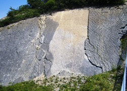 Picture: Ripples on Limestone Beds, The Ripple Beds. Author's Photo.
Miners supplemented their income from collecting and selling Wren’s Nest fossils. The 1850 Bentley Directory records three shops selling such fossils in Dudley town centre. These included the popular trilobite - Calymene blumenbachii, known locally as the ‘Dudley Bug’ or ‘Locust’, which adorns the town’s coat of arms. Today, Wren’s Nest fossils can be found in museums and collections worldwide. Since the 18th Century they have appeared in many publications and scientific papers.
During the 1830s, eminent palaeontologist Sir Roderick Impey Murchison visited Wren’s Nest and Castle Hill to study the Wenlock Series. Stratigraphically describing every fossil, his work revealed over 600 species and 30 major taxonomic groups. Today, Wren’s Nest represents the type locality for 186 fossil species, of which 87 are found nowhere else.
Murchison’s book ‘The Silurian System’ was published in 1839, earning him the nickname ‘King of Siluria’, and launched in Dark Cavern beneath Wren’s Nest to an audience of learned academics, sponsors and locals. His work would lead to a local Dudley fossil collection being assembled and the establishment of the Dudley and Midland Geological Society in 1842 - precursor to the Black Country Geological Society, founded in 1975. Murchison also encouraged the movement for a Museum of Geology in Dudley, which led to the establishment of the Dudley Museum and Art Gallery in 1912.
Geoconservation
 Friends Group volunteers and reserve wardens hosted the Wren’s Nest 60th Anniversary celebrations, a year ago next month, at the former Mons Hill College Campus. The event included talks from the Friends’ Group, Graham Worton (Keeper of Geology) and guest speaker Professor Richard Fortey. After lunch activities included either a guided walk or fossil hunting on the reserve.
Picture: Prof. Richard Fortey cutting the Wren’s Nest 60th Anniversary Cake. Courtesy of Dudley Museum Services.
Ongoing conservation work encourages local participation to prevent anti-social behaviour, improve access and provide maintenance, education and other promotional activities. Four trails –Wren’s Nest Highlights Trail, Wild Wrosne, Murchison’s Walk and Abraham Darby’s Walk – cross the Reserve, each exploring geological features, wildlife and industrial heritage. Recent lottery funded projects including, ‘The Ripples Through Time Project’ (2006), ‘The Strata Project’ (2007) and ‘The Wrosne Project’ (2008) which continue to inspire and educate visitors. As a flagship site for the Black Country’s ongoing Global Geopark bid, the Wren’s Nest will hopefully continue to be appreciated for at least another 60 years.
Acknowledgements
Thanks to Dudley Museum Services for the use of photographs and for help with the finer points of this article.
Author
 Andrew Harrison is Senior Geotechnical and Geo-Environmental Consultant at Rodgers Leask Environmental. He is field secretary and Vice Chair of the Black Country Geological Society (BCGS). E: [email protected]