A new philosophico chorographical chart of East-Kent by Christopher Packe (1743)
 Geoscientist 22.07 February 2012
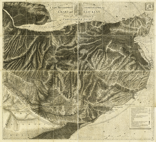
This black and white chart (its author, Christopher Packe, ‘indignantly refused to call it a map’ ) is one of the oldest in the Society’s collection and was ground-breaking for its time. Originally from St. Albans, Packe (1686 – 1749) settled in Canterbury in 1726 where he was a practicing physician until his death. On ‘many otherwise tedious journeys’ around his Kent practice he became interested in cartography, noting that the structure of the human body, with its ‘Systems of Arteries, Veins, or Nerves’, could be a microcosm for rivers and valleys of the natural world. Where cartographers before him had been concerned with illustrating the shape of the land and points of interest, Packe wanted to show the topography of the region of Kent he knew so well. Using sophisticated methods not previously employed, he single-handedly surveyed the whole area, measuring heights above sea level with a barometer, and in so doing created the first geomorphological map in the world. With a polar co-ordinate system centred on Canterbury (Packe had taken bearings with a theodolite mounted on top of Canterbury Cathedral) the chart shows the country about fifteen miles around the city, and is highly detailed, with hills and valleys, rivers and woods, as well as various private estates and all other places of habitation. It is also an early example of geological mapping, for although the areas are not shaded as we would see on a modern map, Packe has included the locations of chalk and gravel pits, shore and cliff line springs, and locations where amber and copperas stone had been found. - Michael McKimm
A reproduction print of this map can be purchased from the Picture Library