|
Extract from Greenough’s copy of ‘'Map of the Leinster coal district and the surrounding country' by Richard Griffith for the Dublin Society, (1814). Greenough collection, ref: LDGSL/947/6/F/3.
|

|
Richard Griffith from Archibald Geikie’s ‘Life of Sir Roderick Murchison’ (1875). GSL Library collections.
|
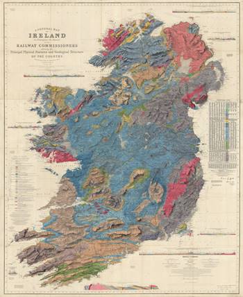
The earliest known geological map of the whole of Ireland was published in the ‘Atlas to accompany the second Report of the Railway Commissioners of Ireland’, 1838. Yet the map’s author, Richard Griffith (1784-1878), had been working on the map from at least 1811 at the behest of his friend George Bellas Greenough, who thought it could be a companion to his own planned ‘Geological Map of England & Wales’.
In between multiple official roles surveying parts of Ireland, Griffith worked on various drafts of his geological map. An early version was compiled for a series of lectures he gave at the Dublin Society in March 1814. At the end of the previous year Griffith had written to Greenough complaining that Alexander Taylor’s map of Ireland was on too small a scale for public exhibition, and asked if Greenough could send him Aaron Arrowsmith's much larger map. Additionally, could Greenough also pencil in any geological observations that he had made during the two men’s travels around Galway and Mayo in the summer? Whichever map was used by Griffith (he is known to have used both at some time or other), it and any of the subsequent drafts have never been traced.

|
|

|
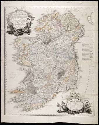
Geological colouring on Taylor's 'A New Map of Ireland', [1813-1820s]. Greenough collection, ref: LDGSL/947/6/F/4. Click to enlarge.
|
|
Richard Griffith’s ‘A general map of Ireland to accompany the report of the Railway Commissioners shewing the principal physical features and geological structure of the country.’ 3rd edition (1855). GSL Library collections. Click to enlarge
|
The map on the left is coloured upon the base map, 'A New Map of Ireland', by Alexander Taylor, published by William Faden in 1793 – the map referred to by Griffith in his letter to Greenough. There is a handwritten key and some notes by Greenough, but no other information is known about it. The colouring which has faded is rather neat and unlike any of Greenough’s own hand coloured maps which are more loosely rendered. The key indicates only nine rock categories - as opposed to the 20 units which are on Griffith’s map of 1838.

|
|

|
Thomas Weaver’s Geological Map of the East of Ireland, [1818] from Weaver, T, “Memoir on the Geological Relations of the East of Ireland”, Transactions of the Geological Society of London, S1, vol 5, 1821. Click to enlarge.
|
|
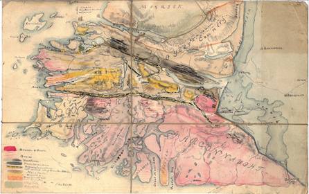
Alexander Nimmo (1783-1832) was another geological surveyor whom Greenough met whilst in Ireland in 1813. Nimmo’s map of Connemara [c.1813] comprising eight lithological units, was also once owned by Greenough. Ref: LDGSL/947/6/F/2. Click to enlarge.
|
The lithology bears some similarity to that which appears on the ‘Geological Map of the East of Ireland' [1818] by Thomas Weaver (1773-1855) who, coincidentally, Griffith accused of plagiarism. Weaver had attended one of Griffith’s lectures in 1816 and, according to Griffith, Weaver’s map reproduced virtually all of his then map’s geological boundaries with only a few additions. Could the Taylor map be a lost copy of one of Griffith’s early draft maps? If not it is certainly one of the earliest geological maps showing the entirety of Ireland.


