Oliver Pritchard, Stephen Hallett and Timothy Farewell* consider a case of ‘the wrong kind of soil’
 All the UK’s local roads are deteriorating, as most readers will no doubt be able to confirm by personal experience. Currently the UK ranks 24th in the world for the quality of its road infrastructure1. Councils are facing increasingly tight budget constraints, and are finding their ability to provide proactive (rather than reactive) road maintenance severely reduced.
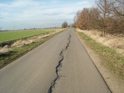
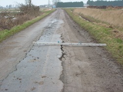
Picture: Longitudinal cracking on Cowbridge Road, nr Bicker (Photo Lincolnshire County Council)
Ninety-eight percent of the UK’s roads are ‘local’. The remaining 2%, including the Highways Agency-controlled strategic motorways and ‘A’ trunk roads, carry the largest volume of traffic. So for most, if not all of us, journeys start and end predominantly on the local road network.
In this article we take the county of Lincolnshire as a case study. Lincolnshire’s remote and agricultural setting underlines the importance of the local network, both economically and socially, especially given the county’s poor railway infrastructure. Road defects therefore create strong public reaction – especially when left untended.
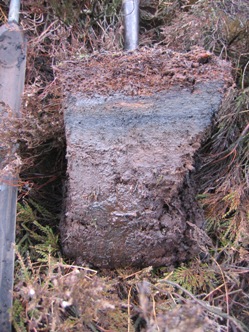 Picture: Fenland peat soil Photo Rodney Burton
A number of factors can lead to road deterioration, from traffic volume, road works (Excavations for infrastructure services), poor construction or reinstatement, cold weather and tarmacadam oxidation to local environmental conditions like soil-type, and proximity to trees and other large vegetation. Lincolnshire’s road condition appears to be among the worst in the UK. The reason for this highlights the role played by the geoscientist.
SOILS
The soils of Lincolnshire and East Anglia are particularly prone to moisture-related soil-shrinkage. During the droughts of 2003 Lincolnshire County Council recorded damage estimated at £7 million affecting over 200 road sections. More recently in 2010-11, more drought conditions caused damage to 154 sites, predominantly in the south-east of the county. Newspapers carried headlines that ran: ‘Is the drought wrecking our roads? As we bask in unseasonably high temperatures, how cracks are appearing on surfaces as soil shrinks’
2.
 Picture: Dendritic relict channels in the Fenlands Imagery copyright 2013 DigitalGlobe Getmapping plc Infoterra Ltd Bluesky Map data copyright 2013 Google
A consortium of East Anglian county councils including Lincolnshire, Norfolk, Cambridgeshire, Suffolk and Peterborough City applied for additional emergency funding after both 2003 and 2010 drought events. The latter bid, totaling £26 million in emergency funding, was unsuccessful. This spurred the Institution of Civil Engineers to regard improving the condition of UK roads as a top priority3, along with damage due to recent cold weather and floods.
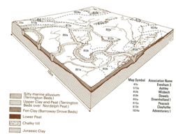 Diagram: F1 Soil associations of the Fenland area (Reproduced from SSEW, 1984)
Highways engineers, asset managers and engineering geologists have predominantly used geological maps to interpret areas of subsidence risk to road networks in the UK. In this feature we suggest and describe practical uses for soil survey data and associated mapping, as an aid to asset-managing the Lincolnshire local road network. We also consider the integration of projected climate change data to aid in modelling soil-related subsidence.
EVOLVED NETWORK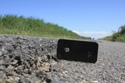
Picture: Smartphone scale of differential settlement Iron Bar Drove nr Spalding Photo O Pritchard
Road construction is nothing new as our Roman roads attest. The inspiration for this feature originated during Oliver Pritchard’s MSc research, which considered the environmental context of historic trackway construction across Irish peat bogs. These trackways, of which many similar examples have been found across Britain, are evidence of man’s early attempts at overcoming the engineering implications of problematic soils.
Many modern roads still follow the course of historic and ancient roadways – known in the trade as ‘evolved’ roads, and this term applies to much of Lincolnshire (and indeed most of the UK). Evolved roads include rural roads, estate roads and distributor roads4. Some will have originated as, and developed from, historic tracks originally constructed during the Roman and Bronze Age periods.
Little, if any, engineering foundation underlies evolved roads. The relatively thin road surface is therefore often placed in direct contact with, and is so directly influenced by, the underlying soil conditions.
SOIL SURVEY MAPPING
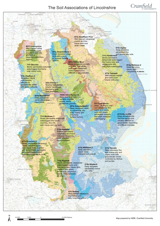 Picture: Soil Associations of Lincolnshire (Copyright NSRI, Cranfield University)
Many people still associate the Soil Survey of England and Wales (SSEW) with agricultural research, which provided the impetus for its earliest activities. SSEW joined Cranfield University in 1987, forming first the Soil Survey and Land Research Centre (SSLRC), and then subsequently the National Soil Resources Institute (NSRI). From this time, efforts were made to diversify the uses to which soils information could be applied. The engineering characteristics of soil provided one such avenue.
NSRI is the custodian of the national soil data archive, and holds many national and regional, as well as localised soil maps, associated data and soil samples. The collection and collation of datasets representing the spatial distribution of soils and their properties, formed the basis for ‘LandIS’, the computerised Land Information System (
www.landis.org.uk)
5. Commencing in the early 1990s, LandIS data have been applied to geohazard application modelling, leading to the development of the thematic ‘Natural Perils Directory’ (NPD)
6.
NPD provides continuous geographical assessment of a range of geohazard assessments across England and Wales (and by incorporating similar data from the James Hutton Institute in Aberdeen, Scotland also).
 Picture: Embankment collapse B1165, Ravens Bank (Photo O. Pritchard)
Assessments are provided for a range of soil perils: clay-shrink swell; silt-frost heave; sand-erosion; and peat-shrinkage. Further assessments of flood-extent alluvial plains, as well as summary wind exposure data, are also included.
The British Standards Institution
7 highlights the usefulness of soil maps for depicting the occurrence of compressible materials, shrinkable clays, and unconsolidated sands. However, engineers in the UK have generally neglected the data produced by the soil survey as it only usually incorporates soil data to maximum depths of approximately 1.5-2m below ground level. The pedological description of soils is also at variance with accepted civil engineering approaches, although attempts have been made to harmonise the respective classifications.
DRIFT
Soil maps also have advantages over geological mapping for representing surface geohazards, portraying certain stratigraphic features not present on geological maps, such as thin superficial drift, or peat layers, sulphate or acid-rich soils and highly expansible subsoils to name a few8. Approximately 50% of Fenland peat is now less than one metre thick. Geological mapping often does not recognise these deposits; consequently, soil maps can provide a more detailed assessment.
Internationally, in many countries (e.g. USA, Australia and the Netherlands) the use of soil survey data for highways design and management is commonplace. US highway departments frequently have their own soil survey teams who produce hazard maps prior to highway construction.
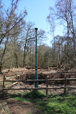 Picture; Holme Fen Post showing peat shrinkage, Holme Fen, Cambridgeshire (Photo O. Pritchard)
Lincolnshire can boast a wide range of soils. Much of East Anglia is underlain by geologically youthful peat, silt and clay soils, derived from previous marine inundations and regressions since the Pleistocene ice ages9. Chalk outcrops and extensive till deposits are found in the north and east of the county in the Lincolnshire Wolds, and limestone occurs to the county’s north and west.
The peat deposits have now wasted to such an extent that underlying silts and clays have become exposed. This can be seen clearly in the creek patterns observed in aerial photographs. These fossilised tidal creek and historic river courses are known as ‘roddons’, whose formation and distribution have been recorded extensively10. Roddons are predominantly silt rich, being generally less susceptible to ground movement processes. For this reason road courses have historically followed them, avoiding surrounding clay and peat soils.
Many drivers desire flawless road surfaces, as evidence of their road-fund taxes being well spent; though in 2010-11 only £9.2bn of the £33bn road tax collected was actually spent on the UK’s highways
12. Because it is a subjective assessment, it is not always clear exactly when a road has ‘failed’
11. With the exception of landslides, ‘failure’ does not often occur instantaneously, but as a chronic process occurring over a period of time.
SHRINK-SWELL CLAYS
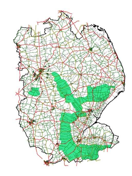 Picture: Drought-susceptible roads in Lincolnshire (Prepared by Lincolnshire County Council)
Despite extensive research regarding expansive clays, these soils remain one of the most persistent threats to the UK built environment, causing some £300 million damage every year. The term ‘clay’ refers to naturally occurring particles that are <2μm in size. Clays are ‘colloidal’ substances – that is to say they have enormous surface-to-surface contact characteristics that make them act as sticky glue. The characteristics of clays susceptible to shrink-swell can be influenced strongly by the mineralogical response to seasonal moisture fluxes. Clay soils with high vermiculite and smectite content are moderately and highly expansive, respectively.
Clay soils vulnerable to shrinkage in Lincolnshire include the Adventurers 2, Downholland, Wallasea 2 and Wisbech associations (detailed information about these can be found at www.landis.org.uk/services/soilsguide). These associations derive from superficial marine alluvium, and are all, to some extent subject to anthropic drainage practices.
In such expansive clays, soil moisture results in expansion (swell) as water is absorbed between the mineral particles, which have a microscopic ‘dinner plate’ appearance. The very minute size of these stacked, plate-like structures permits huge volumes to be retained per unit volume of mineral. Smectite crystals, for example, can have an astonishing surface area of 150 -175 square metres per gram, depending on their state!
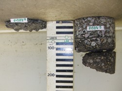
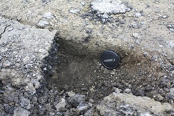 Picture: Thickness of tarmacadam in situ prior to resurfacing treatment unclassified road Nr Grantham. Photo O Pritchard
Decreasing soil moisture causes clay particles to lose adsorbed water and move closer together, resulting in shrinkage. The lateral effects of clay-related soil shrinkage show up as shrinkage cracks in the ground. This, together with less evident vertical shrinkage, can prove particularly damaging to roads; however it is the differential settlement of the substrate that causes most damage.
Roads are designed to be impermeable, because water migrating into road foundations can lead to softening and pumping of the substrate, causing structural failure. During prolonged dryness, moisture within the soil is more readily retained underneath roads, whereas evaporation proceeds unimpeded in the verges, which dry more quickly. Vegetation, especially high water-demand trees, exacerbate this. Greater shrinkage therefore occurs towards the edge of the road than in the centre, resulting in damaging differential settlement. Roads passing over roddons also suffer differential shrinkage as a result of the silt in the roddon not being affected by moisture change, whereas flanking peats and clays are.
 Picture: Subsidence at Childers Lane nr Spalding Photo Lincolnshire County Council
Longitudinal cracking of road surfaces can cause a road to ‘break its back’. Roads are predominantly designed and built to be partially flexible, allowing them to absorb traffic stresses and subtle ground movement. In agricultural areas, the increasing size and weight of agricultural machinery is also putting increased pressures (literally) on the network.
PEAT SHRINKAGE
Peat is known for its poor bearing capacity, a result of large pore spaces and high water content (up to ten times its own mass). When water is lost, significant consolidation may result, especially when overburden is applied (i.e. road structure or traffic loading).
Water loss from peats has been increased by industrial agricultural drainage of the Fenlands since the 1600s. This has resulted in oxidation and mineralisation of peats, leading to untold and irreversible shrinkage. Holme Fen, Cambridgeshire, is a good example of the substantial peat shrinkage loss in the Fenlands.
The resultant lowering of ground level due to soil wastage has, in some areas, left the highways high above the rest of the landscape - particularly those sections that are built on roddons. Such raised sections often have steep banks, with drainage dykes at their base. These factors, together with the presence of shrinkable clays, give rise to slope stability issues, resulting not only in road closures and high remediation costs, but potentially in a threat to human life.
REMEDIATION
 Picture: Varying depths of tarmacadam after coring investigation at Mole Drove Photo Lincolnshire County Council
Many approaches have been adopted to the remediation of roads suffering soil-related problems. One particularly effective treatment has been applied to the A1073 near Crowland, Lincolnshire. Here, the installation of steel reinforcing ‘geogrids’ below the road surface has prevented the damaging effects of ground movement. Before this trial was undertaken, extensive cracks were encountered, thought to be the result of cyclic shrink-swell processes in the underlying soils. This drainage ditches along the sides of the road were also infilled, so reducing slope stability issues.
SOIL HAZARD MAPPING
UK climate projections13 indicate that the UK is likely to encounter hotter, drier summers and wetter, warmer winters in future. For clay soils, this will result in greater soil moisture deficits, promoting more serious shrink-swell. Peat soils will continue to be subject to irreversible shrinkage and oxidation as the water table draws ever lower, exacerbated by farmers needing more irrigation. Lincolnshire’s roads in future will probably be even more at the mercy of soil-related geohazards.
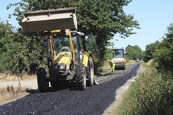 Picture: Resurfacing works at Mole Drove, nr Gedney Hill (Photo O. Pritchard)
The Natural Perils Directory (NPD) does not currently permit the probabilistic modelling of soil subsidence hazards. We aim in our future research to integrate probabilistic climate data with the NPD subsidence perils model, and so allow us to forecast future likely areas of subsidence risk. Incorporating this approach with local road network data will enable us to identify priority areas at risk, aiding asset management strategies for the future. The All Parliamentary Group on Highway Maintenance14 is calling for asset management planning to become mandatory, in return for central government funds for road maintenance. Geoscientists will play a key role in formulating these plans.
In preparation for this, the combining soil-related subsidence knowledge with maps of baseline soil-subsidence risk has allowed Lincolnshire County Council to further develop and re-assess their current asset management and maintenance practices, identifying areas at highest risk of soil-related subsidence and so aiding the selection of appropriate cost-effective treatments.
NEW METHODS
Approaches like that seen near Crowland are relatively expensive and their use site-specific. Although the evolved road network is important, it is predominantly rural with low traffic volumes, and new methods might offer a more general solution. One such method involves in-situ recycling, whereby the existing road is planed, scarified, rolled and a new binding agent applied along with imported surface chippings to provide a new road surface.
As part of a ‘soil-informed’ maintenance strategy, such planed tarmacadam can be used to reinforce road foundations in areas affected by soil shrinkage. Creation of a deeper foundations in problematic areas results in evolved roads that are less likely to interact with soils affected by damaging seasonal or extreme moisture change, so prolonging their life. The added benefit of reduced waste disposal costs, combined with longer road life, should enable the Authority to undertake more proactive road maintenance in future.
Few would envy the role of the many highway asset managers, at the mercy of diverse and problematic ground conditions, and who, under ever tighter budgets, often find their ability to remediate and innovate restricted by fiscal constraints. Prioritisation of highly limited funding is therefore paramount in maintaining road networks, and will remain so for the foreseeable future. Soil map-based evidence, together with future probabilistic climatic scenario projections, can assist this difficult decision-making process.
Acknowledgements
The research associated described in this feature was funded by the UK Engineering and Physical Sciences Research Council (EPSRC) under programme grant EP/I01344X/1 to the UK Infrastructure Transitions Research Consortium (ITRC).
Mike Coates, Mark Heaton and their colleagues at Lincolnshire County Council for introducing us to the soil-related problems faced on Lincolnshire roads and allowing Oliver to visit affected sites, as well as providing many of the illustrations presented.
*National Soil Resources Institute, School of Applied Sciences, Cranfield University, Cranfield, Bedfordshire, MK43 0AL
References
- World Economic Forum. 2012. Global Competitiveness Report.
- Daily Mail. 29th February, 2012. Is the drought wrecking our roads? As we bask in unseasonably high temperatures, how cracks are appearing on surfaces as soil shrinks. Available at: http://www.dailymail.co.uk/news/article-2107734/Is-drought-wrecking-roads-As-bask-unseasonably-high-temperatures-cracks-appearing-surfaces-soil-shrinks.html
- Institution of Civil Engineers. 2013. State of The Nation: Transport.
- ADEPT (Association of Directors of Environment, Economy, Planning and Transport). 2009. Climate change and evolved pavements. CSS Research Project No. 78.
- Keay CA, Hallett SH, Farewell TS, Rayner AP and Jones RJA. (2009). Moving the National Soil Database for England and Wales (LandIS) towards INSPIRE Compliance. International Journal of Spatial Data Infrastructures Research, 134-155. http://ijsdir.jrc.ec.europa.eu/index.php/ijsdir/article/view/115/131
- Hallett SH, Keay CA, Jarvis MG and Jones RJA. 1994. INSURE: Subsidence risk assessment from soil and climate data. Proceedings of the Association for Geographic Information (AGI National Conference: Markets for Geographic Information. 16.2.1-16.2.7.
- British Standards Institution. 1999. BS5930. Code of practice for site investigation, amendment 2: 2010. London.
- Reeve MJ. 1989. Soils. In: McCall J and Marker B (Eds.). Earth Science Mapping for planning, development and conservation. Graham and Trotman, London.
- SSEW. 1984. Soils and their use in Eastern England. Bulletin No. 13. Harpenden. 450pp.
- Smith DM, Zalasiewicz JA, Williams M, Wilkinson IP, Redding M and Begg C. 2010. Holocene drainage systems of the English Fenland: roddons and their environmental significance. Proceedings of the Geologists Association. Vol. 121, pp. 256-269.
- Brown SF. 2013. An introduction to asphalt pavement design in the UK. Proceedings of the Institution of Civil Engineers: Transport. Vol. 166, pp. 189-202.
- Institution of Civil Engineers. 2013. Spending Review 2013: A briefing from the Infrastructure Alliance. Available at: http://www.ice.org.uk/Information-resources/Document-Library/Spending-Review-2013-A-briefing-from-the-Infrast
- Jenkins G, Murphy J, Sexton D et al. 2009. UK Climate Projections: Briefing Report. Met Office Hadley Centre, Exeter, UK.
- All Party Parliamentary Group on Highway Maintenance. 14th October 2013. Managing a valuable asset: improving local road condition. Available at: http://www.highwaysmaintenance.org/images/library/files/APPG_Report_-_Managing_a_valuable_asset.pdf